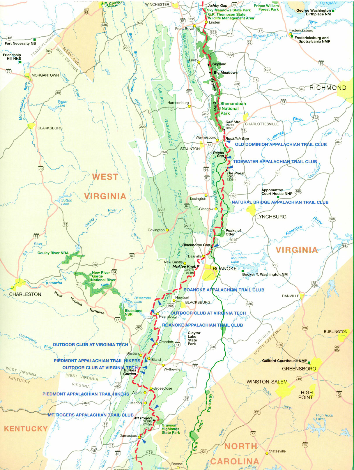
Appalachian Trail Terrain in Virginia
One-fourth of the Appalachian Trail lies in Virginia. It varies from easy hiking to very difficult rock scrambling, from busy national parks to isolated wilderness areas.
NORTHERN VIRGINIA
In northern Virginia, the Appalachian Trail follows a long, low ridge, including a notoriously strenuous “roller-coaster” section south of Snickers Gap. It is less heavily traveled and is crossed by fewer roads than the Trail in Maryland. This is one of the best places on the A.T. for “spring break” hikes. Download Spring Break Hiking (PDF) to find out more about hiking on the A.T. in March and April.
The northern Virginia section stretches 54 miles from the Virginia/West Virginia state line south to Shenandoah National Park.
SHENANDOAH NATIONAL PARK
Shenandoah National Park, with 104 miles of well-graded and well-maintained Trail and climbs rarely exceeding 500 or 1,000 feet, is excellent for beginning hikers and is noted for its many vistas and abundant wildlife. A variety of side trails provides excellent opportunities for one- or two-day circuit hikes.
Nearby Skyline Drive has many waysides and concessions for resupply stops. The park gets very busy during weekends and in late October, during peak foliage-changing season. Park facilities close from late November through March; when snow shuts down Skyline Drive, the entire park may become inaccessible except on cross-country skis or snowshoes. Backcountry permits are required when camping in the park.
CENTRAL VIRGINIA
South of Shenandoah, the A.T. parallels the Blue Ridge Parkway. The farther south it goes, the more difficult the hiking becomes; the treadway is well-graded, but includes a number of 2,000- and 3,000-foot climbs. Mature timber, high summits, and spectacular wilderness can be found in the George Washington National Forest, north of Roanoke. The Trail then leaves the parkway and travels west across the Great Valley of the Appalachians through the Jefferson National Forest to the Allegheny Plateau, a splendid wilderness trip.
Central Virginia features many noteworthy points, with views from unusual rock formations and outcroppings and some of the northernmost balds on the Trails. Noteworthy peaks include Humpback Rocks, Three Ridges, the Priest, McAfee Knob, and Dragon’s Tooth. This section is more rugged and remote than the Shenandoah, but easier and more accessible than the Trail in Southwest Virginia.
The Central Virginia section covers 226 miles from the southern end of Shenandoah National Park south to Pearisburg.
SOUTHWEST VIRGINIA
Throughout the Mt. Rogers region in southwest Virginia, where the Trail moves into the southern Appalachians, the floral displays of rhododendron and azalea in June and July are outstanding. The state’s highest mountain, Mt. Rogers, an area of spectacular highland meadows, routinely receives snowfall from October to May, making it considerably colder, wetter, and snowier than other areas of Virginia.
The northern portion of this section provides some of the A.T.’s best opportunities for solitude; toward the southern end the open meadows of the Mt. Rogers high country (5,000 feet and above) attract many visitors. At the southern border is the quintessential “Trail town,” Damascus, Virginia.
The Southwest Virginia section of the Trail covers 166 miles from Pearisburg south to Damascus.
Difficulty Ratings for A.T. Sections
Because the A.T. spans a great variety of terrain, ranging from relatively flat and easy, to extremely difficult, the following scale was created as a general guide:
1 = Flat and smooth
2 = Flat terrain but uneven treadway, or slight elevation change
3 = Moderate elevation change, but well graded trail, or flat trail with very rough treadway
4 = Strenuous climbs, but of moderate duration, or short but steep climbs
5 = Lengthy graded climbs, alternating with easier sections
6 = Extended climbs that may last hours or shorter climbs with difficult footing
7 = Includes rock scrambling that is relatively easy and of short duration
8 = Includes rock scrambling that is somewhat challenging
9 = Rock scrambling that is difficult and extended
10 = Use of hands required for extended periods of climbing, footing precarious, and leaping may be required — not recommended for those with fear of heights and not in good physical condition. Shorter hikers may be at a disadvantage
| At a Glance | |
| A.T. mileage | 550.3 miles (includes 20+ miles along Virginia/West Virginia border) |
| Difficulty rating | 2-8 |
| Elevation | 265 – 5,500 feet |
| Guidebook | Appalachian Trail Guide to Maryland and Northern Virginia with Side Trails Appalachian Trail Guide to Shenandoah National Park with Side Trails Appalachian Trail Guide to Central Virginia Appalachian Trail Guide to Southwest Virginia |
| When to go | Northern Virginia: April through early June, September through early November. Summer heat and humidity can be oppressiveShenandoah: April—June, September, October. July and August are bearable except during a heat wave.Central Virginia: April—June and September—October. July and August are bearable except during a heat wave.
Southwest Virginia: May—October.
|
| Trail clubs | Northern Virginia and Shenandoah:Potomac Appalachian Trail Club Pine Grove Furnace State Park, Pa., to Rockfish Gap, Va.Central and Southwest Virginia: Old Dominion Appalachian Trail Club Tidewater Appalachian Trail Club Natural Bridge Appalachian Trail Club Roanoke Appalachian Trail Club Outdoor Club of Virginia Tech Piedmont Appalachian Trail Hikers Mt. Rogers Appalachian Trail Club |