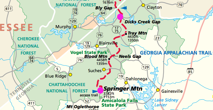
Appalachian Trail Terrain in Georgia
The Appalachian Trail in Georgia traverses the Chattahoochee National Forest. This area features rugged wilderness hiking, with highway crossings spaced about a moderate day’s journey apart. Hiking includes many steep ups and downs, but the Trail is lower here than in nearby North Carolina and Tennessee, mostly along ridges of between three and four thousand feet.
Those tempted by the southerly latitude to plan spring-break hikes in March will often be disappointed to find cold rain, sleet, and snow.
Difficulty Ratings for A.T. Sections
Because the A.T. spans a great variety of terrain, ranging from relatively flat and easy, to extremely difficult, the following scale was created as a general guide:
1 = Flat and smooth
2 = Flat terrain but uneven tread-way, or slight elevation change
3 = Moderate elevation change, but well graded trail, or flat trail with very rough tread-way
4 = Strenuous climbs, but of moderate duration, or short but steep climbs
5 = Lengthy graded climbs, alternating with easier sections
6 = Extended climbs that may last hours or shorter climbs with difficult footing
7 = Includes rock scrambling that is relatively easy and of short duration
8 = Includes rock scrambling that is somewhat challenging
9 = Rock scrambling that is difficult and extended
10 = Use of hands required for extended periods of climbing, footing precarious, and leaping may be required — not recommended for those with fear of heights and not in good physical condition. Shorter hikers may be at a disadvantage
| At a Glance | |
| A.T. mileage | 76.4 miles |
| Difficulty rating | 6 |
| Elevation | 2,510 – 4,461 feet |
| Guidebook | Appalachian Trail Guide to North Carolina – Georgia |
| When to go | April and May. September and October. Georgia is crowded with thru-hikers in March and April, and spring-break crowds make this even worse. Heat and humidity can be oppressive in July and August. |
| Trail clubs | Georgia Appalachian Trail Club |